Estimated read time: 12 minutes | Category: Science Mysteries | Last updated: June 2025
The Drawings That Can Only Be Seen From the Sky
From the ground, you see almost nothing. Brown stones, pale desert surface, the occasional shallow depression. Walk across the Nazca plateau in southern Peru and you would not know that beneath your feet — or rather, spread across the desert around you — is one of the most extraordinary collections of geoglyphs ever created by human hands.
From the air, everything changes.
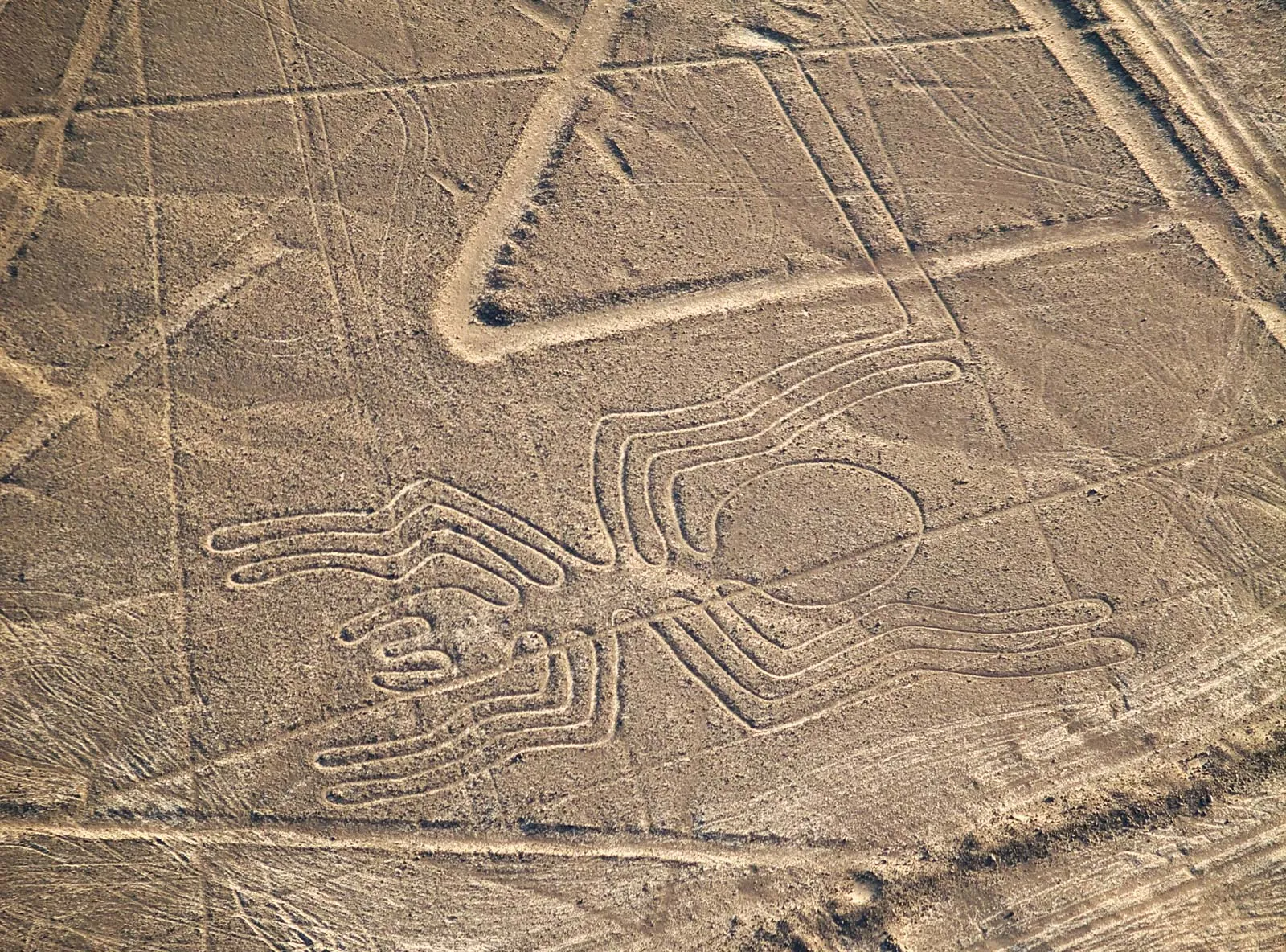
From above, the plateau reveals itself as a vast canvas — covered in hundreds of lines, geometric shapes, and figurative drawings of breathtaking scale and precision. A hummingbird with a wingspan of 96 metres. A condor stretching 135 metres from wingtip to wingtip. A spider the size of a football field. A monkey with a spiralling tail. Geometric lines extending for kilometres across the desert surface, so straight that for decades researchers could not explain how they were drawn without aerial survey equipment.
The Nazca Lines were made by the Nazca people, who inhabited this region of Peru from approximately 100 BCE to 800 CE. Their makers are known. Their method has been convincingly demonstrated. Their purpose remains one of the most genuinely contested questions in archaeology — generating theories ranging from astronomical calendars to ritual walking paths to water management systems, and attracting the inevitable fringe claim that they were built for or by extraterrestrials.
Here is what the evidence actually shows.
What We Know For Certain
- [FACT] The Nazca Lines are a collection of geoglyphs located on the Nazca Plateau in the Ica Region of southern Peru, covering an area of approximately 450 square kilometres.
- [FACT] The lines were created by removing the reddish-brown iron oxide-coated pebbles from the desert surface to reveal the lighter yellowish-grey ground beneath — a simple but enormously labour-intensive process.
- [FACT] The geoglyphs include approximately 70 figurative designs — animals, plants, and human figures — and hundreds of geometric shapes including straight lines, triangles, trapezoids, and spirals.
- [FACT] Radiocarbon dating of organic material found at the sites, combined with analysis of pottery styles associated with the lines, dates the majority of the geoglyphs to between approximately 200 BCE and 700 CE.
- [FACT] The Nazca Lines were designated a UNESCO World Heritage Site in 1994. Their exceptional preservation is due to the extreme aridity of the Nazca plateau — one of the driest places on Earth — and the absence of wind strong enough to disturb the surface.
- [FACT] Experiments conducted since the 1980s have demonstrated that the geometric lines could have been created using simple tools and techniques available to the Nazca people — wooden stakes, rope, and basic surveying methods.
- [FACT] No scientific evidence of extraterrestrial involvement in the creation of the Nazca Lines has been found. Their creation is consistent with human labour using period-appropriate technology.
The Lines — What Is Actually There
[FACT] The Nazca geoglyphs fall into two broad categories: the figurative designs and the geometric lines and shapes.
The Figurative Geoglyphs
[FACT] The approximately 70 figurative geoglyphs include representations of animals found in the Nazca region and beyond — a hummingbird, condor, pelican, parrot, spider, monkey, whale, dog, iguana, snake, and various fish and plants. Several human or humanoid figures have also been identified.
[FACT] The figurative geoglyphs are drawn in a continuous line that rarely crosses itself — a technique that creates a recognisable image from above while appearing as a simple path at ground level. This single-line technique is consistent with the drawings being intended as processional paths — routes to be walked rather than pictures to be viewed.
[FACT] The famous “Astronaut” figure — a humanoid image sometimes cited by alien theorists as depicting a being in a spacesuit — is now understood by archaeologists to likely represent a human figure in a ceremonial context, possibly a shaman or deity. The features interpreted as a “helmet visor” are consistent with indigenous artistic conventions for depicting faces.
The Geometric Lines and Shapes
[FACT] The geometric elements — which significantly outnumber the figurative designs — include straight lines extending for up to 9 kilometres across the desert, large trapezoidal cleared areas, triangles, and spirals. Some lines radiate outward from central points or hills in patterns that researchers have described as ray centres.
[FACT] The straight lines are remarkable for their precision — deviating by less than two metres over kilometres of length. This precision has been used by some to argue that aerial oversight was required for their creation. Experiments have demonstrated, however, that the lines could have been laid out using simple wooden stakes and rope lines extended from fixed points — a technique within the capabilities of any organised pre-Columbian culture.
How They Were Made
One of the most persistent mysteries around the Nazca Lines — how such enormous, precise designs could be created without aerial perspective — has been largely resolved by experimental archaeology.
[FACT] The creation method is now well understood. The Nazca people removed the reddish-brown desert pebbles from the surface and piled them at the edges of the lines, revealing the lighter subsoil beneath. The colour contrast between the cleared surface and the surrounding desert creates the visible lines. This is a straightforward process requiring no special technology — only organisation, labour, and time.
[FACT] Experiments conducted by multiple teams — including work by the late German mathematician Maria Reiche, who dedicated her life to studying the lines, and more recent experimental work by other researchers — have demonstrated that the straight lines could be laid using wooden stakes and rope. A team at ground level can extend a straight line over kilometres using sighting poles and intermediate markers — the same basic surveying technique used throughout the ancient world.
[FACT] The figurative designs are more complex to explain from a construction perspective, but experiments have demonstrated they could have been created by scaling up small designs using a grid system — dividing the design into sections and transferring each section to the ground at the required scale. This technique was used in ancient Egypt, Greece, and other cultures for scaling architectural drawings.
[FACT] A 2019 study by Japanese researchers from Yamagata University — who have been mapping the Nazca plateau using drone technology — identified 143 previously unknown geoglyphs in addition to the approximately 70 previously known figurative designs, significantly expanding the known scope of the site.
The Purpose — What the Evidence Shows and Does Not Show
This is where genuine scientific disagreement begins. The method of creation is largely understood. The purpose of the lines — particularly the large geometric shapes — remains contested.
The currently leading hypothesis among archaeologists is that the lines — particularly the figurative geoglyphs — functioned as ritual walking paths. The single-line construction technique of the figurative designs is consistent with paths designed to be walked rather than viewed. The Nazca culture had strong traditions of ritual landscape modification, and walking particular paths as part of religious ceremonies is documented in many pre-Columbian cultures. The lines’ association with ceramic offerings and other ritual deposits at their edges supports this interpretation. [FACT] This theory is supported by multiple lines of archaeological evidence and is the consensus view among the majority of researchers who have studied the site.
Researcher David Browne and others have proposed that the lines are associated with water and fertility rituals — specifically with prayers and ceremonies directed toward the mountain gods (Apus) believed to control rainfall and water flow in the Andes. The trapezoidal shapes, which point toward the mountains, and the association of several lines with underground water sources (puquios) support this interpretation. [FACT] The Nazca region is extremely arid, and water management was critically important to the Nazca civilisation. The association between the lines and water rituals is supported by archaeological context.
Maria Reiche, who spent decades measuring and cataloguing the lines, proposed that they functioned as an astronomical calendar — with specific lines aligned to the rising and setting points of the Sun, Moon, and stars at astronomically significant dates. Some alignments have been confirmed — several lines do point toward astronomical events. [FACT] However, statistical analysis by astronomer Gerald Hawkins in the 1960s found that the number of confirmed astronomical alignments was not significantly greater than would be expected by chance — given the enormous number of lines and possible alignments. The astronomical calendar theory is now considered partially supported but overstated by most researchers.
The theory popularised by Erich von Däniken’s 1968 book Chariots of the Gods — that the Nazca Lines were built as landing strips or signals for visiting extraterrestrial spacecraft — has no archaeological or scientific support. The lines’ construction is fully consistent with human labour using period-appropriate technology. The “landing strip” theory also misunderstands aircraft physics — no aircraft, terrestrial or extraterrestrial, would need the precision of Nazca-style clearing rather than a simple flat surface. The association between the lines and extraterrestrials has been comprehensively rejected by archaeology and is not taken seriously by the scientific community.
The Nazca People — Who Were They?
[FACT] The Nazca civilisation flourished in coastal and inland southern Peru from approximately 100 BCE to 800 CE. They were a sophisticated pre-Columbian culture known for their extraordinary polychrome pottery, their complex textile production, and their extensive system of underground aqueducts called puquios — which channelled water from the Andes to the desert floor and allowed agriculture in an extremely arid environment.
[FACT] The Nazca had no writing system — their history and beliefs are reconstructed entirely from their material culture, the geoglyphs, and comparison with other Andean cultures. This absence of written records makes definitive interpretation of the lines’ purpose impossible — we cannot ask the Nazca what they meant.
[FACT] The Nazca civilisation declined significantly around 500-600 CE, possibly due to a combination of climate change — a prolonged El Niño event — and the destruction of the huarango tree forests that had stabilised the local ecosystem. The geoglyphs continued to be used after the Nazca period and were modified and added to by successor cultures including the Huari.
[ANALYSIS] Understanding the Nazca Lines requires understanding the Nazca worldview — one in which the physical landscape, the celestial bodies, the mountains, and the underground water sources were all interconnected elements of a spiritual geography. The lines almost certainly had meaning within this worldview that we cannot fully reconstruct from the outside. The most honest answer to “why did they build the lines” is probably: for reasons that made complete sense within a belief system we no longer have access to.
The Preservation Crisis
[FACT] The Nazca Lines face significant preservation threats. In December 2014, Greenpeace activists entered the restricted area around the hummingbird geoglyph during a climate conference and left footprints in the surrounding desert. The Peruvian government filed criminal charges — even brief access to the surrounding surface can cause damage that takes centuries to heal in the Nazca plateau’s fragile ecosystem.
[FACT] Illegal road construction, agricultural encroachment, and the expansion of nearby Nazca city have damaged portions of the geoglyph field. UNESCO and the Peruvian Ministry of Culture have implemented protection measures, but enforcement is difficult across such a large area.
[FACT] Climate change poses an additional threat — increased rainfall events in the normally hyper-arid Nazca region have caused erosion damage to some geoglyphs in recent years. Events that would be minor on most surfaces can significantly damage the fragile pebble-removal geoglyphs of the Nazca plateau.
The New Discoveries
[FACT] The Yamagata University research team — using drone photography, artificial intelligence image analysis, and ground survey — has dramatically expanded the known inventory of Nazca geoglyphs. Between 2016 and 2023 they identified over 300 previously unknown geoglyphs, predominantly smaller figurative designs that are less visible from altitude than the famous large images.
[FACT] Many of the newly discovered geoglyphs are located along ancient paths and near human settlements — supporting the interpretation that they were associated with ritual activities connected to daily life and movement through the landscape rather than large-scale ceremonial performance.
[FACT] In 2020 the team identified a geoglyph of a humanoid figure that appears to be in a fighting or dancing posture — adding to the diversity of figurative designs known at the site and suggesting the lines’ creation spanned a longer period and wider range of purposes than previously understood.
Conclusion
The Nazca Lines were made by the Nazca people, using simple tools and organised labour, over a period of several centuries. Their construction required no alien technology, no aerial surveillance, and no knowledge beyond what an organised and sophisticated pre-Columbian culture could accumulate. This is not a mystery of how.
Why is more interesting — and more honestly uncertain. The ritual walking path interpretation is well supported by evidence. The water and fertility ritual connection is plausible and archaeologically grounded. The astronomical alignments exist but are not as systematic as early researchers hoped. The full meaning of the lines — particularly the enormous geometric shapes — remains genuinely contested among serious researchers.
What is certain is that the people who made them lived in a world where the relationship between the human, the divine, the celestial, and the terrestrial was not separate — where drawing a hummingbird on the desert floor might be as purposeful and as cosmologically significant as any prayer. We see the marks they left. We do not fully see the world they lived in when they left them.
The lines remain. The plateau preserves them. And from above, they still have the power to make the people who see them for the first time feel that they are looking at something whose full meaning is just beyond reach.
Written and reviewed by the MysteryVerse editorial team. Facts sourced from UNESCO World Heritage Site documentation, published research by the Yamagata University Nazca Lines research project, Anthony Aveni’s astronomical analysis, Johan Reinhard’s ritual landscape research, and the German Archaeological Institute’s ongoing Nazca Lines project.
The Nazca Lines are a UNESCO World Heritage Site. Visiting the restricted areas without authorisation is illegal under Peruvian law and causes irreversible damage to a site of global significance.
Spotted an error? Contact us and we will correct it promptly.